A new tool for measuring public transport accessibility outside London
For many years London has had a simple yet effective tool (PTAL) for measuring and visualising accessibility to the public transport network, yet this has not been available outside the capital. That is, until now.
Steer Davies Gleave has just developed the Public Transport Accessibility Level Calculator (PTAL-C) for Yorkshire Passenger Transport Executive (METRO) in partnership with South Yorkshire PTE. The work to develop PTAL-C was part of the Regional Improvement and Efficiency Partnership study (RIEP) which analysed and promoted best practice in integrating transport and land use planning in Leeds and Sheffield city regions.
What does the PTAL Calculator do?
PTAL-C provides a very quick and simple but also detailed and accurate measure of the accessibility of a location to the public transport network, taking into account walk access times and service availability. It can be used to measure and visualise the density of the public transport network at any location, or across a wide geographic area.
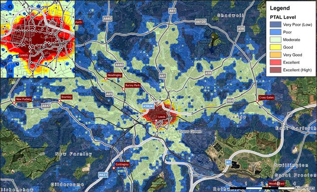
The outputs of PTAL-C can be a ‘score’ indicating how accessible a place or area is; a database showing the detailed PTAL-C scores for a range of points (such as Postcodes); or a map which provides a visualisation of the accessibility levels across an area (see map below).
How is it being used?
METRO is currently promoting the use of the PTAL Calculator at both strategic and local levels. At a strategic level PTAL-C has been used to strengthen the evidence base for districts in their development of their Local Development Frameworks, in particular for Core Strategies and Site Allocation Development Plan Documents.
On a local level METRO is looking to work more closely with districts in West Yorkshire to use the tool in development control for major planning applications. The tool gives the Local Planning Authorities a more informed measure of access to the public transport network, as opposed to the traditional walk distance buffers that were previously used.
METRO has also supported the use of PTAL-C as an assessment tool within the Local Transport Plan 3.
How else could it be used?
Because the tool assesses the accessibilities of origin locations, it is particularly suitable for assessing accessibility for potential development areas or for identifying areas of social exclusion (perhaps by combining the PTAL-C data on the coverage of the public transport network with our Transport Needs Index which shows where there is the greatest underlying need for affordable public transport.
Work to date has focused upon the morning peak but the assessment could equally consider non-peak times. Given the importance of supported services at such times, the tool could therefore be used to evaluate options for targeting support. Conversely, it could potentially be used to assess the impact of changes to commercially-registered services.